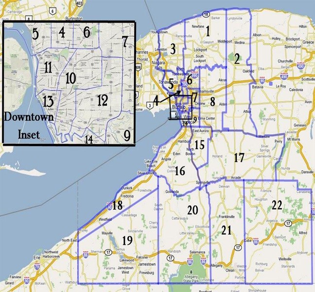
| 1 | Eastern Niagara County, not Niagara Falls | District 1 Map |
| 2 | Western parts of Orleans, Genesee and Wyoming (North of Rte 20A) Counties | District 2 Map |
| 3 | Niagara Falls Area - Eastern Niagara County | District 3 Map |
| 4 | Kenmore, Town of Tonawanda | District 4 Map |
| 5 | Riverside, Tonawanda near River, North Tonawanda, Grand Island | District 5 Map |
| 6 | UB South Campus Area, Tonawanda, Amherst North of Sheridan, East Amherst | District 6 Map |
| 7 | Snyder, Williamsville, Cheektowaga north of William | District 7 map |
| 8 | Clarence, Akron, Depew, Alden, Elma | District 8 map |
| 9 | W.Seneca & Cheektowaga, E of I-90,W of Transit Rd, S of Losson & North of Milestrip | District 9 Map |
| 10 | Buffalo, East Side & Kensington Area | District 10 Map |
| 11 | Buffalo, West Side between North/Porter & Amherst St | District 11 Map |
| 12 | Cheektowaga, Sloan, Lovejoy, Babcock & the Valley | District 12 Map |
| 13 | Buffalo, West Side, Allentown, Downtown | District 13 map |
| 14 | South Buffalo, Lackawanna, Blasdell | District 14 Map |
| 15 | East Aurora, Orchard Park, North Boston | District 15 Map |
| 16 | Southern Erie County, W of Rte 219, Hamburg, Angola, Eden, Gowanda | District 16 Map |
| 17 | SW Erie & S Wyoming Counties, Holland, Springville, Arcade, Perry | District 17 Map |
| 18 | Chautauqua County along Lake Erie shore, Ripley to Silver Creek, Brocton, Dunkirk/Fredonia, Forrestville, Westfield | District 18 map |
| 19 | Remainder of Chautauqua County, Mayville, Jamestown, Lakewood, Chautauqua, Fluvanna, Mayville, Sherman | District 19 Map |
| 20 | Western Cattaraugus County, Salamanca, Ellicottville, Little Valley | District 20 Map |
| 21 | Eastern Cattaraugus County, Olean, Franklinville | District 21 Map |
| 22 | All of Allegany County | District 22 Map |
